Difference between revisions of "Forum:Update to InfoboxSector Template"
| Line 18: | Line 18: | ||
:::I might be able to add a "you are here" overlay to the map site, e.g. do an IFRAME but add in highlight_sx/sy/hx/hy parameters at the end of the URL to position an overlay image. Think about what you'd need. [[User:JoshuaBell|JoshuaBell]] 23:11, 26 January 2008 (UTC) | :::I might be able to add a "you are here" overlay to the map site, e.g. do an IFRAME but add in highlight_sx/sy/hx/hy parameters at the end of the URL to position an overlay image. Think about what you'd need. [[User:JoshuaBell|JoshuaBell]] 23:11, 26 January 2008 (UTC) | ||
:::: See http://travellermap.blogspot.com/2008/02/jump-maps-you-are-here-and-more.html - I've added Jump maps and a preliminary "You Are Here" indicator (API is likely to change). Feedback appreciated. | :::: See http://travellermap.blogspot.com/2008/02/jump-maps-you-are-here-and-more.html - I've added Jump maps and a preliminary "You Are Here" indicator (API is likely to change). Feedback appreciated. | ||
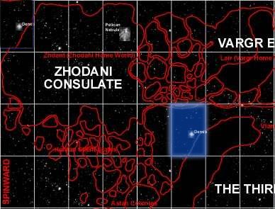
| + | :That You Are Here looks excellent for a planet or possibly a subsector location, for the sector orientation I was thinking of either a quarter image with the sector highlighted, or the whole map, for example: [[Image:Q1Deneb.jpg]] | ||
==Jump maps == | ==Jump maps == | ||
Revision as of 15:02, 6 February 2008
Just in case everyone missed it, last week I was in contact with Joshua Bell, the operator of the Traveller map site. Traveller map is a google maps style (interactive, scrollable, zoomable) map of Traveller's charted space. The coolest map site ever.
I figured out how to work the traveller map iframe interface into the wiki. And Joshua gave permission to create the external links. So I updated the InfoboxSector to include the Traveller map link. This means the map in the Sector infobox is interactive, scrollable, zoomable, and other cool things.
My plan is (at some point) to do the Subsectors (more zoomed map to start with) and perhaps a J-6 (or J-4) map for the worlds. Assuming the worlds are actually in the Traveller map database.
Just want to know what you think. Tjoneslo 17:03, 21 January 2008 (UTC)
- This looks good. It can take some time to load up though. We will also need to add this to the InfoboxSectorNoSS template as well. Dcorrin 19:37, 21 January 2008 (UTC)
- There are a number of changes I've made to the InfoboxSector that have not been reflected in the InfoboxSectorNoSS. I'd just as soon update the InfoboxSector to omit the Subsector table as try and keep two Infoboxes in synch. Tjoneslo 19:58, 21 January 2008 (UTC)
- It may be a good idea to increase the size of the window vertically to show the adjacent sectors and also eliminate the pic of the sector (upper right) from the screen, because we'll be able to get the same info form the template. Overall great job and excellent collaboration.--Sstefan 01:36, 22 January 2008 (UTC)
- I am thinking of replacing the traveller map image with a "you are here" type image, basically at a smaller scale. Dcorrin 14:24, 22 January 2008 (UTC)
- I might be able to add a "you are here" overlay to the map site, e.g. do an IFRAME but add in highlight_sx/sy/hx/hy parameters at the end of the URL to position an overlay image. Think about what you'd need. JoshuaBell 23:11, 26 January 2008 (UTC)
- See http://travellermap.blogspot.com/2008/02/jump-maps-you-are-here-and-more.html - I've added Jump maps and a preliminary "You Are Here" indicator (API is likely to change). Feedback appreciated.
- I might be able to add a "you are here" overlay to the map site, e.g. do an IFRAME but add in highlight_sx/sy/hx/hy parameters at the end of the URL to position an overlay image. Think about what you'd need. JoshuaBell 23:11, 26 January 2008 (UTC)
- I am thinking of replacing the traveller map image with a "you are here" type image, basically at a smaller scale. Dcorrin 14:24, 22 January 2008 (UTC)
- That You Are Here looks excellent for a planet or possibly a subsector location, for the sector orientation I was thinking of either a quarter image with the sector highlighted, or the whole map, for example:

Jump maps
I wanted to use the Jump Maps for the world articles. But I need to write up the DPL code to extract the sector/hex information. I've not had time for it just yet. But I have played with it and it looks great.
One new fix/feature: In order to get the jump map to fit in the Infobox, I'm started with a J6 map at a small scale (~32 pixels/parsec). At that scale only the high pop (or important) worlds have names. I'd like to override that, at least for the selected hex.
An integration problem: Since the URL doesn't end with a ".jpg" or other image format, the default way of displaying the link is as a link rather than as an image. Also Wiki doesn't like externally hosted images. So I may need to reproduce the renderTravellerMap() code for the jump maps. Tjoneslo 14:02, 6 February 2008 (UTC)